• Skip to primary navigation
  • Skip to content

Raiden Resources

ASX: RDN

  • About
    • Directors & Management
    • Corporate Directory
    • Corporate Governance
  • Projects
    • Serbia
      • Stara Planina
      • Donje Nevlje
      • Pirot
      • Majdanpek
      • Bor
      • Zupa
    • Bulgaria
      • Kalabak
      • Zlatusha
  • Investors
    • Announcements
    • Company Reports
    • Company Presentations
  • Contact

Kalabak

Location

The Kalabak license (191 km2) is located in the Haskovo Province (Kardzhali District) of southern Bulgaria.  Geologically, the project locates in the mineral endowed Tertiary Western Tethyan orogenic belt.

Ownership

Raiden announced on 15 July 2019 that it has signed an Option agreement with QX Metals Corporation (“QX”) over the Kalabak project in Bulgaria. QX, a TSX-V listed Company, is the 100% holder of the Kalabak license, through its 100% owned Bulgarian entity, Zelenrok EOOD. The agreement provides Raiden with an opportunity to earn up to 75% in the Kalabak project.

Exploration Status

Historical exploration in the district by Bulgarian State agencies was mainly focused on the base metal (Pb-Zn) potential, with no focus on precious metals or porphyry related copper mineralisation. Balkan Minerals and Mining (“BMM”) explored the area from 2002 to 2004 and followed the exploration evolution of the district to the epithermal gold model.  BMM’s work program included outcrop sampling and the drilling of three short diamond drill holes.  QX’s reconnaissance work and preliminary exploration from 2009 to 2017 confirmed epithermal gold mineralisation in the permit area.  Raiden commenced exploration in August 2019 with soil geochemical  surveying and plans to advance the numerous prospects to the “drill ready” state during 2020.

Highlights

The Kalabak license covers highly prospective Tertiary rocks in the under-explored Bulgarian portion of the Western Tethyan Metallogenic Belt.  Limited historical exploration in the area by previous explorers and recent discoveries in the same belt outside of Bulgaria, substantiated that the Kalabak permit is highly prospective for copper porphyry and epithermal gold mineralisation.  Recent gold discoveries at Ada Tepe and Rozino, within 10 km of the Kalabak permit, further underline the prospectivity of the project.  Raiden’s initial work program in the Kalabak area defined four large alteration systems with coincident elevated levels of copper and/or gold.  Soil sampling and ground-geophysical surveying is presently ongoing in the permit area to prepare targets for drill testing.

Maps

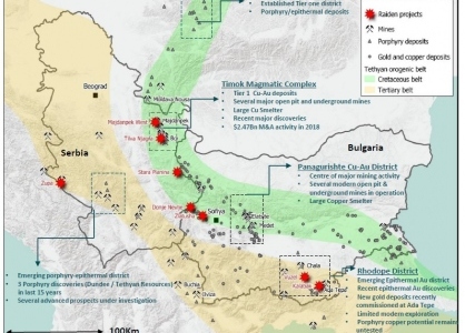
Map 1: Locations of the Company’s projects in the Western Tethyan orogenic belts and relative to known porphyry and epithermal gold and copper deposits. Map 1: Western Tethyan Belt.
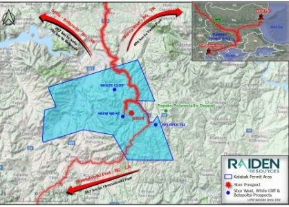
Map 2: The location of the Kalabak permit (191 km2) in southern Bulgaria. Sea ports can be reached via well maintained and tarred roads. Map 2: Kalabak Location.
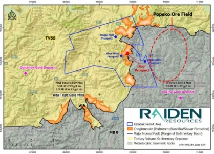
Map 3: : The geology of the Kalabak permit and the locations of four prospective alteration zones.  Mines and mineral deposits in the vicinity of the permit area are also shown. The licence covers an Eocene and Oligocene (Tertiary) volcano-sedimentary package and metamorphic basement rocks. Map 3: Kalabak Geology.
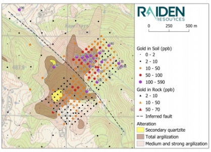
Map 4: Sbor Prospect alteration mapping and the results of Raiden’s recent soil sampling program (gold). The prospect is defined by a 2.2 km2 zone of intense argillisation and silicification (silica cap). A conspicuous and undrilled gold/copper/molybdenum in soil anomaly exists north-east of the inferred fault. Map 4: Sbor Main Gold.
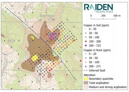
Map 5: Sbor Prospect alteration mapping and the results of Raiden’s recent soil sampling program (copper). The prospect is defined by a 2.2 km² zone of intense argillisation and silicification (silica cap). A conspicuous and undrilled gold/copper/molybdenum in soil anomaly exists north-east of the inferred fault. Map 5: Sbor Main Copper.
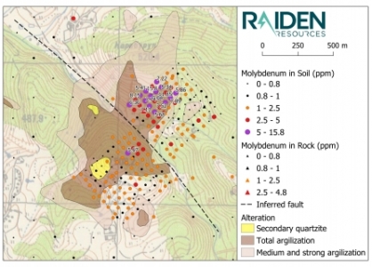
Map 6: Sbor Prospect alteration mapping and the results of Raiden’s recent soil sampling program (molybdenum). The prospect is defined by a 2.2 km2 zone of intense argillisation and silicification (silica cap). A conspicuous and undrilled gold/copper/molybdenum in soil anomaly exists north-east of the inferred fault. Map 6: Sbor Main Molybdenum.
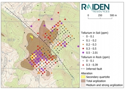
Map 7: The south-western portion of the soil sampling grid returned an intense tellurium anomaly in an area with extensive silica alteration. This geochemical response and alteration is interpreted to represent a setting which is relatively higher up in the system, compared to the responses and alteration observed in the north of the prospect. Map 7: Sbor Main Tellurium.
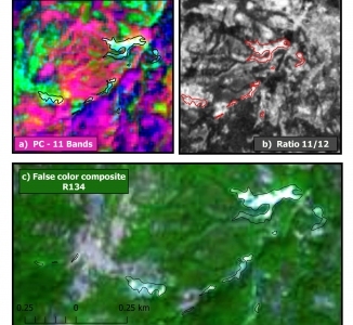
Map 8: Images of processed satellite data showing the argillic and advanced argillic alteration zones that define the Sbor West Prospect. Processing of Sentinel 2 data (13 Bands) was carried out by Raiden’s technical team and defined a one kilometre long and northwest trending corridor along which at least seven zones of argillic alteration exist (black and red outlines). The Band 11/12 Ratio (b) and the False Colour Composite (c) together clearly map the Sbor West alteration zones. Map 8: Sbor West Satellite.
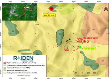
Map 9: Geologically, the Sbor West Prospect lies at the bottom contact of a unit of Tertiary volcano-clastic andesites (Tc-VSS) with the underlying Podrumsche conglomerate. The alteration is limited to the andesites, while the underlying conglomerate appears to be unaltered. Near-by subvolcanic porphyritic andesite stocks intruded the volcano-clastic andesites (Svo) and may relate to a larger concealed feeder intrusive body underneath the Sbor West Prospect. During 2017 QX carried out a stream sediment program in the permit area and found that the only sample taken in the catchment of the Sbor West Prospect (green point) yielded an anomalous gold value. Map 9: Sbor West Geology.
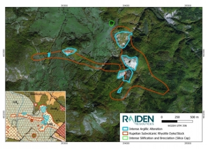
Map 10: The geology (lower left corner) and satellite image of the White Cliff epithermal gold prospect. The satellite image indicates that outcrops of intense argillic alteration (blue outlines) extend over an area of approximately 1.5 km by 1 km in size. Relicts of a potential silica cap of this epithermal alteration system outcrop on a hilltop in the northern portion of the prospect (green outline). The geological map of the prospect indicates that the alteration outcrops are in association with a sub-volcanic intrusive (rhyolite, brown outline) Map 10: White Cliff Alteration.

Prospectivity and Geology

The permit area covers an Eocene to Oligocene volcano-sedimentary pull-apart basin and underlying basement gneiss and amphibolite. The volcano-sedimentary package dips shallow to the north-west and consists of clastic sediments, volcanic rocks of andesitic composition and limestones. Late subvolcanic and porphyritic andesite stocks intruded the volcano-sedimentary package at several locations and point to larger concealed feeder intrusives and copper porphyry potential at depth.

Recent exploration in the vicinity of the Kalabak permit for epithermal gold led to the notable discovery of the Ada Tepe and Rozino projects. Dundee’s Ada Tepe deposit, located southwest of Kalabak, achieved commercial production in March 2019 and Velocity Minerals’ Rozino deposit, southeast of the Kalabak permit, hosts an inferred gold resource of 13 million tonnes grading 1.37 g/t gold. Mineralization at both projects is hosted by the same altered sedimentary and volcanic rocks that underlie the Kalabak permit. The company therefore believes that the Kalabak permit holds significant potential for epithermal gold mineralisation.

Copper porphyry mineralisation has been discovered within the Tertiary Dinaride-Aegean segments in all the neighboring countries, with the exception of Bulgaria. Given that the Kalabak project is situated within a similar geological setting and that it displays significant alteration features and geochemical finger prints, which indicate the presence of copper-gold mineralisation, the Company believes this is the consequence of a lack of exploration, rather than a lack of geologic potential.

Exploration

The Company’s geologists initially reviewed geological maps and historical exploration data, and conducted a reconnaissance visit of the Kalabak project. More recently the company completed a follow-up soil sampling program over the Sbor and Belopoltsi prospects. This initial work resulted in the definition of four prospects:

Sbor Main

  • Confirmed copper-gold porphyry target;
  • Infill geo-chemistry and mapping defined a multi-element porphyry footprint;
  • Epithermal gold prospect defined on the south-western side of the Sbor prospect; and
  • Prospect nearing drill ready status
  • Satellite imagery outlines large hydrothermal alteration zone;
  • Alteration zone coincident with elevated gold concentration in stream sediment; and
  • Geological observations point towards potential for epithermal gold mineralisation and possibly towards deeper seated copper- porphyry style mineralisation.

Sbor West

  • Satellite imagery outlines large hydrothermal alteration zone;
  • Alteration zone coincident with elevated gold concentration in stream sediment; and
  • Geological observations point towards potential for epithermal gold mineralisation and possibly towards deeper seated copper- porphyry style mineralisation.

White Cliff

  • Prospect defined by a 1.5km by 1km zone of argillic alteration;
  • Alteration zone possibly related to an epithermal gold system; and
  • The prospect remains untested with no significant historical work undertaken on the prospect.

Belopoltsi

  • On trend with the “Popsko Ore Field”;
  • Defined by three distinct gold/silver in soil anomalies;
  • Rock samples of quartz vein and breccia yielded anomalous concentrations up to 2.2 g/t Au; and
  • Observations support the definition of a low sulphidation epithermal gold prospect.
Gallery

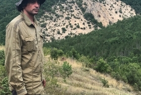
Photo 1:  Raiden’s geologists at work in the Kalabak permit area. Photo 1: Geologists at work.
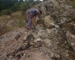
Photo 2:  Geological mapping in the Kalabak permit area. Photo 2: Kalabak field mapping.
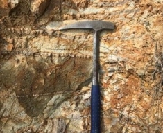
Photo 3:  Sbor Main brecciated porphyritic andesite with abundant sheeted quartz veining. This style of alteration, fracturing and quartz veining is typical for the type of alteration system proximal to a porphyry intrusion. Photo 3: Sbor Main stockwork.
Photo 4:  Sbor Main sheeted quartz veining and intense silicification in conglomerate. Photo 4: Sbor Main veining.
Photo 5:  Sbor Main sheeted and laminated quartz veining. Photo 5: Sbor Main veining.

Photo 6:  A massive and approximately 40 cm wide barite/galena vein at the entrance of an exploration adit in the Sbor Main area developed by the Bulgarian State. Photo 6: Sbor Main adit.
Photo 7:  Sheeted quartz vein laminations and argillic alteration in float from the Sbor Main prospect. Photo 7: Sbor Main veining.
Photo 8:  View of the Sbor West project area.  A large area of altered andesite can be seen in the background. Photo 8: Sbor West view.
Photo 9:  An outcrop of unaltered Podrumsche conglomerate in the foreground and the overlying altered (brown) andesite in the background (Sbor West). Photo 9: Sbor West conglomerate.
Photo 10:  An outcrop of polymictic Podrumsche conglomerate in the Sbor West area. Photo 10: Sbor West conglomerate.

Photo 11:  Large scale pervasive argillic alteration appears to affect the growth of vegetation in the Sbor West area. Photo 11: Sbor West alteration.
Float of porphyritic and silicified andesite with greater than 1 % disseminated pyrite Sbor West. Photo 12: Sbor West pyrite.
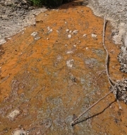
Photo 13:  Natural acid drainage caused by oxidation of sulphides in the altered rock in the Sbor West catchment. Photo 13: Sbor West acid drainage.
Photo 14:  Google satellite image of the name-giving lenses (cliffs) of silification within the White Cliff argillic alteration zone. Photo 14: White Cliff satellite view.
Photo 15: Photo of the name-giving lenses (cliffs) of silification within the White Cliff argillic alteration zone. Photo 15: White Cliff view.

Photo 16:  Vuggy and silicified rhyolite that can be found outcropping on a hilltop just to the north of the White Cliff argillic alteration zone. This outcrop has been interpreted to be the silica cap of the White Cliff epithermal alteration system. Photo 16: White Cliff vuggy quartz.
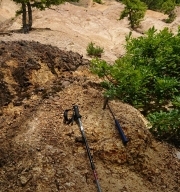
Photo 17:  Outcrop of intense argillic alteration in rhyolite in the White Cliff prospect area. Photo 17: White Cliff alteration.
Photo 18:  Outcrop of an east-west striking, silicified rhyolite dyke with 1-2% disseminated pyrite in the White Cliff area. This type of sub-volcanic rhyolite intrusion may be the source of the heat and fluids that resulted in the hydrothermal alteration in the White Cliff prospect area. Photo 18: White Cliff felsic dyke.
Photo 19:  Silicified rhyolite with 1-2% disseminated pyrite from the White Cliff area. Photo 19: White Cliff pyrite.
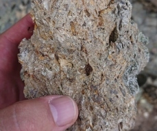
Photo 20: “Lattice bladed” textures in Belopoltsi silicified rock sample. This texture is typical of late replacement of carbonate by silica and indicative of a low temperature, low sulphidation epithermal depositional environment. Photo 20: Belopoltsi “bladed” texture.

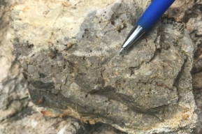
Photo 21:  Hydrothermally and tectonically brecciated rhyolite from the Belopoltsi prospect. Photo 21: Belopoltsi breccia.

© 2021 Raiden Resources · Site by aWhite Design